West Texas Geological Society
2022 Spring Field Trip
Old Rocks, New Ways: Analogs for Conventional, Unconventional, and Saltwater Disposal Reservoirs in the Precambrian-Devonian of Far West Texas and Southeast New Mexico
2022 WTGS Spring Field Trip April 28 – May 1
Field Trip Leader:
Andy Roark
Chevron North America E & P

Sponsor:

Additional sponsors are welcome! Please contact WTGS if interested.
If you are not a member or would like to send in your payment, please send your payment along with the registration form below to the WTGS office:
WTGS - 2022 Spring Field Trip
P.O. Box 1595
Midland, TX. 79702
TRIP ABSTRACT & ITINERARY:
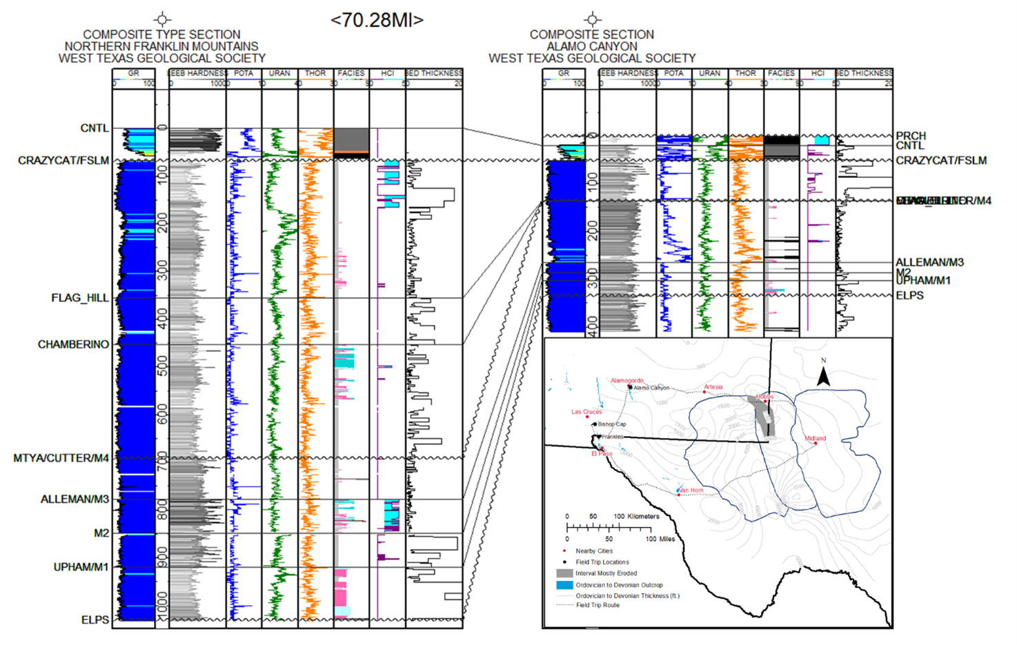
WTGS is pleased to announce the 2022 Spring Field Trip immediately proceeding AAPG’s Southwest Section meeting. “Old Rocks, New Ways” revisits classic type sections of the lower Paleozoic with an eye towards recent industry problems – and adds exciting new stops never visited on prior trips! In the Franklin, Organ, and Sacramento Mountains, age equivalent strata to the Woodford Shale, Wristen Group, Fusselman, Montoya, and Ellenburger outcrop in nearly identical thickness and facies to their subsurface equivalents. As such, these outcrops are direct analogs to present-day unconventional reservoir and saltwater disposal targets, as well as conventional reservoirs in legacy fields.
On this trip, the group will identify and trace significant stratal surfaces in this section, which covers more than 100 million years of geological time, along a distal to proximal transect for nearly 100 miles! WTGS will present newly-collected spectral gamma ray and geomechanical profiles of the type sections, clarifying subsurface correlations and revealing facies correspondence to log signatures.
Abandoned fluorite mining excavations reveal 3-dimensional natural fracture networks. Cross-cutting relationships unambiguously demonstrate relative timing of fracture sets and subsequent mineralization and mirror observations from subsurface image logs and cores in the Permian basin. These data are critical for understanding the tectonic history and present-day stress regime of the area. Plus, each tunnel has uniquely colored fluorite crystals!
The Percha (Woodford) Shale in the area transitions from a distal, anoxic setting to a proximal, oxidized setting with abundant clastic influx. Consequently, these outcrops offer a rare window into lateral facies relationships in self-sourced unconventional reservoir systems. Excellent exposures permit geosteering simulations at the scale of a horizontal well!
The trip will depart from Midland on the afternoon of Thursday, April 28 and return Sunday evening, May 1. The group will stay in beautiful Las Cruces with access to an excellent restaurant and bar scene. Participant cost of $750 includes lodging, transportation (rental trucks), and lunch, snacks, and drinks in the field.
IMPORTANT: on two days, the group will be hiking for several miles in full sun exposure and will be away from the vehicles for most of the day. Participants must be physically capable of hiking up to 6 miles over trails with uneven footing and of carrying sufficient food and water for the duration of the hike.
|
ITINERARY
|
|
Day 0 (Thursday, April 28): Depart Midland for hotel in Las Cruces
|
|
Day 1 (Friday, April 29): Northern Franklin Mountains
- · Complete Precambrian-Devonian stratigraphy – over 3,000’ of rock and 100 million years of time!
- · Fusselman and Montoya type sections
|
|
Day 2 (Saturday, April 30): Bishop Cap
- · Simulated geosteering in the distal mudstone facies of the Percha (Woodford) Shale
- · 3D natural fracture networks and cross-cutting relationships in old mining tunnels
- · Tectonic history and sequence of events in the Permian Basin area
- · Vulcanism and hydrothermal ore emplacement
|
|
Day 3 (Sunday, May 1): McKelligon and Alamo Canyons
- · Seismic-scale collapse features in the top El Paso Group (Ellenburger)
- · Regional correlation of stratal surfaces
Depart from Alamogordo and return to Midland through beautiful Cloudcroft
|